World
Storms Sweeping Across the Northeast Bring Heavy Rain and Strong Winds

This Video Is Trending Right Now
New York City was under a tornado watch on Tuesday afternoon, and so were several other towns and cities across the Northeast as severe storms threatened to bring torrential downpours, flash flooding, powerful winds and large hail to areas that were still reeling from similar storms over the weekend.
It was the first tornado watch issued for New York City since September 2021, according to Evan Bentley of the National Weather Service’s Storm Prediction Center. Parts of the city were also under a flash flood warning until 7:30 p.m., and the Weather Service warned that rain could fall at a rate of up two inches an hour.
Brief tornado warnings also had emergency officials and residents on edge in Kentucky, Ohio, Pennsylvania, West Virginia and Virginia on Thursday. There were no immediate reports of widespread damage.
“There were already two reports of brief tornadoes in Northern New Jersey, so the environment has proven that it can produce tornadoes today,” Mr. Bentley said.
Mr. Bentley warned that the evening would likely bring more storms.
“It’s not time to let your guard down yet, as we still have multiple rounds of additional storms possible,” Mr. Bentley said just before 5 p.m.
Hundreds of flights were delayed or canceled because of the storms. At 6 p.m. Tuesday, ground stops were in place at airports in Baltimore, Boston, New York, Philadelphia and Washington, D.C., according to the Federal Aviation Administration.
Tornado sirens in Essex County sent residents into their basements as a warning stretched across the area beginning at 3:15 p.m. Online group chats spread news of a possible funnel cloud sighting near Montclair State University. Farther south, at least one tornado was reported in Morris, N.J., just after 2 p.m.
A funnel cloud is officially called a tornado only if it touches the ground, and once one is confirmed, experts determine its strength on the five-point enhanced Fujita scale by measuring the damage it has caused.
Millions of people from Kentucky to New England were at some risk from the storms on Tuesday. Strong winds from thunderstorms earlier in the day had already downed trees and caused power outages across the region, but major disruptions had been minimal by midday.
The worst was expected during a second round of storms that is forecast to last from Tuesday afternoon through the evening.
At 5 p.m., thunderstorms were moving across eastern Pennsylvania and were expected to make their way east. Additional storms were moving through the Ohio Valley, spread across southern Illinois and Kentucky, and heading toward Virginia.
Mr. Bentley said the peak for the second round of storm activity would run from about 5 p.m. until 10 p.m.
A watch means the ingredients are in place for tornadoes to develop. A warning is more urgent, and it means that a tornado, flood or other hazard is currently taking place, or is about to, and that people should seek shelter.
Forecasters said that if tornadoes were reported around New York City, they would most likely be weak. In many places, forecasters said, the greatest threat was likely to come from damaging wind gusts, some potentially as strong as those of a hurricane.
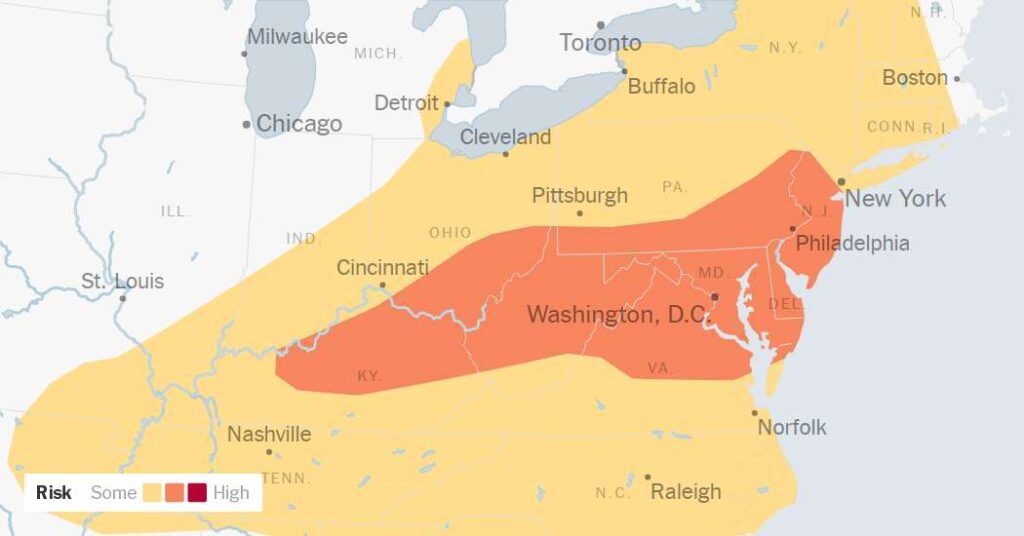
Philadelphia, Baltimore, Pittsburgh and Washington were all in the bull’s-eye of an area that is likely to experience the most severe weather. New York, Cleveland and Nashville were in the next ring out, where the forecast still had meteorologists concerned, but the risk was slightly lower.
In Pennsylvania, the State College office of the Weather Service warned that the storms could reach a level of intensity to which only one or two systems rise each year. Though the storms were forecast to move through the Mid-Atlantic and Northeast relatively quickly, forecasters said that repeated rounds of storms could pass over the same areas, producing high rainfall amounts that could lead to flash flooding.
Tropical Storm Bertha, more than 500 miles away, is pumping extra moisture up from the Gulf and toward the Northeast, adding to the potential for higher rainfall amounts.
The Weather Service office in New York warned that up to two inches of rain could fall per hour, potentially leading to flash flooding in urban areas. A flood watch was in effect for the area from New York City and southeast Pennsylvania to northern New Jersey through late Tuesday night.
In the New York area on Saturday, potent storms dropped large amounts of rain over just a few hours, leading to flash flooding across the region. More than three inches of rain was recorded in Jersey City and Manhattan, and one weather station near Newark recorded four and a half inches.
Videos shared on social media showed people caught driving in floodwaters, including a box truck that became partly submerged under an overpass on the Brooklyn-Queens Expressway.
How to prepare


Plateau lawmaker denies dumping APC

Trump Administration Is Said to Reach Broad Nuclear Deal With Saudis

Election Denier Wins G.O.P. Nomination to Be Arizona’s Top Election Official

Couple among 5 who drowned in Ohio river tragedy ID’d as their young children left without any living relatives in US

Rep. Andy Biggs wins GOP primary for Arizona governor

Trump Pick Wins G.O.P. Nomination to Challenge Arizona Governor

An OpenAI job listing described ambitions to build an ad network. Then the company deleted the references.

 Society2 days ago
2026 Ballon d’Or: Top 4 players to win award after World Cup final revealed
- Society2 days ago
Pepper Seller Caught On Camera Applying Pepper On Newborn Baby As Rituals To Usher Her Into The Business
- World2 days ago
Spain earns $51 million for World Cup win and runner-up Argentina gets $34 million as total payout for all 48 teams hits record-high $871 million
- Investigation15 hours ago
65-year-old married female teacher blindfolded and tied 10-year-old schoolboy to bed before having s3x with him
- Society3 days ago
Nigerian Lady Weeps Uncontrollably On Social Media As Her Bank Account Gets Hacked, Life Savings Wiped Out Except ₦194
- Investigation16 hours ago
"I ‘m fine and healthy" – Video of late Mary Habila debunking her d3ath rumours 3 days before she d!ed at Umahi’s residence
- Investigation11 hours ago
âBusinesses are dy!ng in South Africa. Nobody is making money – South African man decries low patronage days after anti-immigrant protest
- Investigation3 days ago
Woman allegedly k!lls husbandâs mistressâ two-month-old baby in Benue